
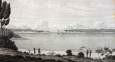
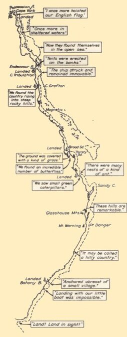
Botany Bay
|
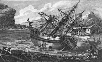
Careening the beached HMB Endeavour
|
EXCERPTS FROM CAPTAIN JAMES COOK’S JOURNAL
A SELECTION OF ENTRIES from 29 April to 18 June and 22nd August 1770
Sunday 29 April 1770
Cook’s arrival at Botany Bay:
In the PM winds southerly and clear weather with which we stood into the bay and anchored under the South shore about 2 Mile within the entrance in 6 fathoms of water.
Saturday 5 May 1770
In the PM I went with a party of Men over to the North shore and while some hands were hauling the saine a party of us made an excursion of 3 or 4 miles into the Country or rather along the Sea Coast. We met with nothing remarkable. Great part of the Country for some distance in land from the sea Coast is mostly a barren heath diversified with marshes and Morasses ... In the AM as the wind still continued northerly I sent the yawl again afishing and I went with a party of Men into the Country but met with nothing extraordinary.
Sunday 6 May 1770 - Cook departs from Botany Bay:
The great quantity of New Plants collected by Mr Banks and Dr Solander in this place occasioned my giving it the name of Sting Ray Harbour (later Botany Bay). It is … Capacious, safe and commodious.
During our stay in this Harbour I caused the English Colours to be displayed on shore every day and an inscription to be cut out upon one of the trees near the watering place setting forth the Ships name, date &Ca . Having seen everything this place afforded we at daylight in the Morning weighed (anchor) with a light breeze at the north-west and put to sea and, with the wind soon after coming to the Southward, we steered along shore (on the) north-north-east.
Cook sights Port Jackson:
... at Noon we were by observation … about 2 or 3 Miles from the land and abreast of a Bay, or Harbour, wherein there appeared to be safe anchorage which I called Port Jackson. It lies 3 leagues to the northward of Botany Bay …
Monday 7th May
Cook sights Broken Bay (entrance to the Hawkesbury River)
Little wind southerly and serene pleasant weather … At sunset, the Northernmost land in sight (was) some broken land that appeared to form a Bay … This Bay I named Broken Bay.
Saturday 12 May 1770
Winds southerly a gentle breeze. In the PM as we run along shore we saw several smooks a little way in land from the Sea and one upon the top of a hill which was the first we have seen upon elivated ground sence we have been upon the coast. At sun set we were ^in 23 fathom water and about a League and a half from the land, the northermost part of which we had in sight bore N 13° East and three remarkable large high hills lying continguous to each other and not far from the shore NW bore NNW As these hills bore some resemblence to each other we call'd them the Three Brothers ... they are of a hieght sufficent to be seen 14 or 16 Leags.
Wednesday 15 May 1770
Fresh gales at SW, WSW and SSW in the PM had some heavy squals attended with Rain and hail which oblig'd us to close reef our Topsails. Between 2 and 4 we had some small rocky Islands between us and the land the southermost lies in the Latitude of 30°.. 210' and the northermost in 29°..58' and about 2 Leagues or more from the land... A tolerable high point of land bore NWBW distant 3 Miles - this point I named Cape Byron / it may be known by a remar[k]able sharp peaked Mountain Iying inland.
Monday 4 June 1770
At Noon we were about 3 Leagues from the land and by observation in the Latitude of 19°..47' So Cape Gloucester — bearing S 63° East distant 71/2 Leagues — I have named Whitsunday's Passage, as it was discoverd on the day the Church commemorates that Festival and the Isles which form it Cumberland Isles — in honour of His Royl Highness the Duke of Cumberland --
Saturday 9 June 1770
...The point of land we were now abreast off I call'd Cape Grafton / Latde 16°..55' So Longde 214° 11' west / it is tolerable high land and so is the whole coast for 20 Leagues to the southward and hath a very rocky surface which is thinly cover'd with wood - In the night we saw several fires along shore and a little before noon some people
Tuesday 12 June 1770 - stuck on a coral reef
Fortunatly we had little ^wind fine weather and a smooth Sea all these 24 hours, which in the PM gave us an oppertunity to carry out the two bower Anchors the one on the Starboard quarter and the other right a stern- got blocks and tackles upon the Cables and brought the falls in a baft and hove taught- by this time it was 5 oClock in the PM, the tide we observed now begun to rise, and the leak increased upon ^us which obliged us to set the 3rd Pump to work as we should have done the 4th also but could not make it work --At 9 oClock the Ship righted and the leak gaind upon the Pumps considerably‡ however I resolv'd to resk all and heave her off in case it was — practical and accordingly turnd as many hands to the Capstan & windlass as could be spared from the Pumps and about 20' past 10 ^oClock the Ship floated and we hove her into deep water having at this time 3 feet 9 Inches water in the hold - ^This done I sent the Long boat to weigh take up the stream anchor - got the Anchor but lost the Cable among the rocks, after this turn'd all hands to the Pumps the leak increasing upon us. but before 8 oClock in the AM Morn^ing they the pumps gain'd ^considerably upon the leak. In the Morning ^We now hove up the best bower but found it impossible to save the small bower so cut it away at a whole Cable - got up the fore topmast and fore yard warped the Ship to the SE and at a 11 got under Sail and Stood in for the land with a light breeze at ESE some hands employ'd sewing ockam wool &Ca into a lower Studding sail to fother the Ship. others emplo'd at the Pumps which still gain'd upon the leak --
‡This was an alarming and I may dsay terrible, circumstance and threatend immidiate destruction to us as soon as the Ship was afloat.
Monday 18 June 1770 - at Endeavour River
Fresh gales and clowdy with showers of rain. At 1 PM the Ship floated and we warped her into the harbour and moor'd her along side of a Steep beach on the south side. Got the anchors Cables and All the Hawsers a shore - In the AM made a stage from the Ship to the shore - errected two tents one for the Sick and the other for the Stores and Provisions - landed all the empty casks and part of the Provisions - and sent a boat to haul the sene who return'd without success ...
For intermediary journal entries, log onto the website listed below (or copy and paste the URL).
22 August 1770 - Torres Strait and Possession Island
Wednesday 22d Gentle breezes at EBS and clear weather ... At 4 oClock we anchor'd about a Mile and a half or 2 Miles within the entrance in 61/2 fathom clear ground distant from the Islands on each side of us one mile, the Maind land extending away to the SW, the farthest point of which that we could see bore from us St 48° West and the South-wester-most point of the Islands on the NW side of the Passage bore St 76° West between these two points we could see no land so that we were in great hopes that we had at last found out a Passage into the into the Indian seas, but in order to be better informd I land^ed with a party of Men accompan'd by Mr Banks and Dr Solander and land upon the Island which lies at the SE point of the Passage: before and after we landed Anchor'd we saw a number of People upon this Island arm'd in the same - manner as all the others we have seen except one man who had a bow and a bundle of Arrows the first we have seen on this coast. from the appearence of these People we expected they would have opposed our landing but as we approached the Shore they all made off and left us in peaceable posession of as much of the Island as served our purpose.
After landing I went upon the highest hill which however was of no great height, yet not less than twice or thrice the height of the Ships Mast heads but I could see from it no land between SW and WSW so that I did not doubt but there was a passage. I could see plainly that the Lands laying to the NW of this passage were composed of a number of Island of various extent both for height and circuit rainged one be hind a nother as far to the Northward and Westward as I could see which could not be less than 12 or 14 Leagues. Having satisfied myself of the great Probabillity of a Passage, thro' which I intend going with the Ship and therefor may land no more upon this Western Eastern coast of New Holland and on the Western side I can make no new discovery the honour of which belongs to the Dutch Navigators and as such they may lay claim to it as their property but the Eastern Coast from the Latitude of 38° South down to this place I am confident was never seen or viseted by any European before ^us and therefore by the same Rule belongs to great Brittan Notwithstand I had in the Name of his Majesty taken posession of several places upon this coast I now once more hoisted English Coulers and in the Name of His Majesty King George the Third took posession of the whole Eastern Coast from the above Latitude down to this place by the Name of New South ^Wales together with all the Bays, Harbours Rivers and Islands situate upon the same said coast after which we fired three Volleys of small Arms which were Answerd by the like number by from the Ship ...
Source: http://southsas.nla.gov.au/journals/cook/17700506.html (copy and paste to URL)
Images sourced from the internet
© Arthur Phillip Chapter of Fellowship of First Fleeters 2021-
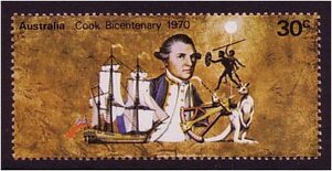
Bicentenary stamp commemorating Cook's discovery of the east coast of Australia
|
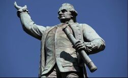
Statue of Captain Cook in Hyde Park, Sydney
|
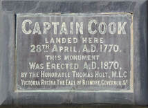
Cook's memorial plaque
at Botany Bay.
|
